Gentrification, and Global Warming, and Housing, Oh My! The Fate of NYC in a Rapidly Changing Climate

By Ruchika Gothoskar

When Hurricane Sandy struck New York in 2012, it pushed a deluge of water through the city, breaking the city’s coastal defences with ease, the storm estimated to have caused $19B of damage and tragically claimed the lives of 43 people. It’s impossible to predict when another storm like this will hit New York, but the likelihood of flooding is rising. In the face of rising sea levels, New York concurrently deals with the insidious nature of gentrification, with communities most affected by both rising sea levels and rising rent being Black communities. While gentrification began in the 1980s and 90s in NYC, the effects of climate change are far more threatening and far more evident now. In Climate Change Adaptation in New York City, Cynthia Rosenzweig and William Solecki write that “environmental conditions as we experience them today will shift, exposing the city and its residents to new hazards and heightened risks. We will be challenged by increasing temperatures, changes in precipitation patterns, rising sea levels, and more intense and frequent extreme events.” By understanding both the racial makeup and cultural significance of communities in New York City, and subsequently categorizing them to see how climate change affects these respective neighbourhoods, we are able to better understand what effect socioeconomic demographics have when it comes to thinking about who stays safe in the face of a changing Earth.

Gentrification is a term that often invokes an image of luxury condos rising from the rubble of public housing developments and independent community run businesses. Climate gentrification, however, throws in the additional factor of a changing global climate that ultimately results in the displacement of low-income people of colour who can no longer afford to live in their homes. Climate gentrification creates a sort of cyclical violence: the prospect of purchasing a home that will be underwater or in the middle of a desert in fifty years is unappealing to homebuyers and makes weather-resilient neighbourhoods more desirable. As a result, homes that are protected from floods by being further north or more inland increase in price, making them unaffordable and unattainable for low-income homebuyers, putting these low-income, and often racialized folks, at risk. Aparna Nathan of Harvard University writes that this cycle “leaves already-vulnerable populations at the mercy of life-threatening weather events”. Ultimately, the cycle of violence is continued and encouraged in the face of both climate change and gentrification, and through the exploration of the connection of the two, we can see exactly what the impact of shoddy politicians and poor infrastructure can do and does to racialized communities.

Image is a side by side of two virtual maps of New York City. The first image, top,  is of NYC in its current state, while the second image, bottom, is a rendered image of NYC in the year 2100, wherein flooding has resulted in buildings being partially submerged and water shown in the middle of the metropolis.
Figure 1, Courtesy of: Google Earth/Climate Central, created with data by the National Oceanic and Atmospheric Agency. Image is a side by side of two virtual maps of New York City. The first image, top, is of NYC in its current state, while the second image, bottom, is a rendered image of NYC in the year 2100, wherein flooding has resulted in buildings being partially submerged and water shown in the middle of the metropolis.

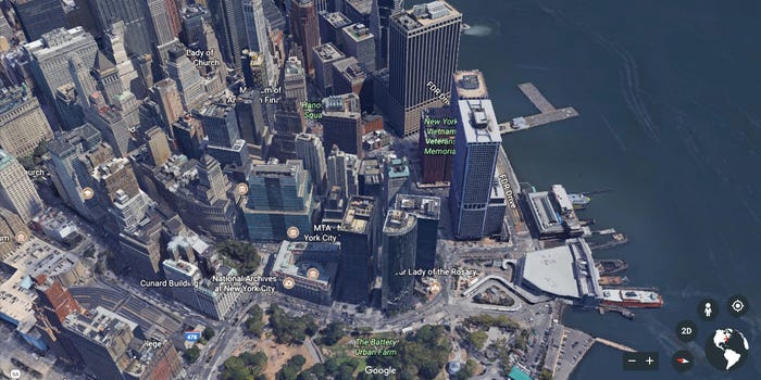
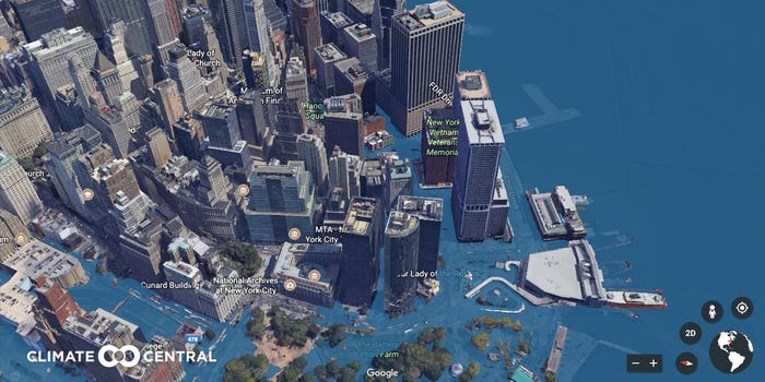
Figure 1 are two side by side maps highlighting the change expected in New York City in coming years. NYC is a coastal city, meaning the proximity to rising water levels is a direct threat to both the infrastructure of the city, but more importantly, its residents. The maps shown above are a rendered image created during Climate Central’s project, Surging Seas: Extreme Scenario 2100, a Google Map extension made to show how major cities would look in coming years, in the face of rising sea levels and melting glaciers. The above maps demonstrate how rising sea levels would mean most of New York City’s major financial area would be flooded with water from the Hudson River seeping into densely populated Brooklyn and the West Village.

Brooklyn, though rather gentrified with young white professionals, is neighboured by boroughs like Queens, and the Bronx; places where there are multi-generational homes of low-income Black and brown families. According to the US Census, the Bronx consists of 43.6% Black families, and 56.4% Latinx, with the median household income being about $40,000 USD per year. While living costs in New York rise and the threat of climate change becomes a reality, those living in neighbourhoods most affected by flooding are able to flee because of their already rapid gentrification, while leaving the low-income racialized people of neighbouring boroughs to fend for themselves. This map of rising sea levels not only creates a tangible visual for New Yorkers to imagine their futures, but puts the stark, unmistakable reality of climate change and its impacts to the forefront. Rohit Jigyasu explains that “while there is a definite need to continue undertaking further research through a collection of highly calibrated data and sophisticated modelling for developing probable climate change induced scenarios for the future, it is equally important to invest in translating our progressively enhanced understanding of climate change risks into simple, achievable practices for day to-day management of cultural heritage”.  Many communities at risk of gentrification are ones that, again, consist of racialized multigenerational families that have lived and thrived in the hustle and bustle of New York City for years. The loss of their home structures or familial homes is indicative of a larger loss of cultural heritage and knowledge of the area and its people passed down through storytelling and community practices.

Ariel map of New York City, with sections highlighted in various colours, aligned with the legend on the right of the image. Each colour on the map shows areas that have public housing, neighbourhoods prone to gentrification, and other municipalities and neighbourhoods throughout NYC.
Figure 2, Courtesy of: Urban Displacement Project, 2021. Ariel map of New York City, with sections highlighted in various colours, aligned with the legend on the right of the image. Each colour on the map shows areas that have public housing, neighbourhoods prone to gentrification, and other municipalities and neighbourhoods throughout NYC.

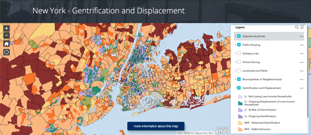
The above map, created by the Urban Displacement Project, maps the New York metropolitan region, while highlighting which neighbourhoods are facing varying forms of displacement. With the layer tool on the right, one can adjust to see everything in each borough of New York City, and New York State, highlighting school zones, municipalities and neighbourhoods, “opportunity zones” where land may be scouted for new development, and ongoing displacement, which marks neighbourhoods that are at risk of gentrification, or are experiencing ongoing gentrification. The Urban Displacement Project writes that “understanding displacement in New York is critical given its housing crisis: rising rent burdens, homelessness, loss of rent-regulated housing, public housing deterioration, and more. With new interest in the New York region from big tech firms like Amazon, Apple, and Google, as well as new federal policies like Opportunity Zones and local actions that seek to harness market-rate development to boost the supply of affordable housing, it is time for New York to look more carefully at displacement”. As previously mentioned, the this cycle of violence propagated by displacement is one further stoked by the impending reality of rising sea levels, changing climates, and a warming Earth.  

Together, both Figure 1 and 2 reveal that communities outside of the metropolitan core are often not seen as facing displacement risks, yet the maps show that some of these towns are undergoing their own displacement processes in what might be seen as a sort of ripple effect that has larger impacts, especially with these metropolitan core communities being the first to be affected by rising water levels. Ultimately, this mapping helps us to understand current gentrification, in the face of impending climate disaster, and adequately understand which communities need the most tangible support rather than new developments.

Journalist Amali Tower aptly notes that while “climate change is a contributing factor to [residents] eventual displacement…it’s important to untangle and decipher the economic reasons alongside the climate reasons so we can effectively advocate for meaningful policy and legislation that protects vulnerable communities from the slow onset impacts of climate change and before, during and after climate fuelled disasters. If not, we not only risk displacement, but also risk losing the diversity – in all its forms – that makes up the entire fabric of what constitutes New York City”.

The protection of New York City is imperative, not only because of its tourist revenue or celebrity pull, but because it is home for so many low income, Black and brown people who know those boroughs like the backs of their hands. Climate change is our responsibility to map, to halt, to manage, for the sake of the preservation of the very thing that makes NYC such a hotspot for visitors and celebrities alike in the first place: its people.

Life in Toxins: A Polluted Species of the St. Lawrence Estuary

By: Ainsley MacLeod

Beluga whale painting
Painting of a St. Lawrence Beluga by author Ainsley MacLeod

The beluga whale is seen in large numbers among the Arctic and Alaskan regions of our planet. The beluga whales inhabiting the St. Lawrence estuary, however, are not found in large numbers and are facing levels of toxicity that are not seen in other habitats of marine life. When it comes to the St. Lawrence Estuary, the beluga whale population is endangered. Since there are hundreds of animal species that are endangered and at risk of being gone and forgotten forever, if the complete population of the beluga whale is not an endangered species, why would anyone focus on the population of the beluga inhabiting the St. Lawrence Estuary of Québec? 

Historically, this population of the beluga whale has been vulnerable to hunting and pollution. In 1979, Hunting of the beluga whale by non Indigenous groups became illegal. Up until then, the biggest danger to this beluga population was commercial hunting. Consequently, with a combination of hunting along with the rapid increase of pollution, the number of beluga whales in the St. Lawrence Estuary drastically dropped from 10,000 before 1885 to an estimated 900 just in 2012. Indicating that “commercial whaling has depleted the population severely.” It might seem as though the direct killing of this species is something that holds the primary responsibility for such rapid depletion of their population, however, since the hunting of “belugas has been banned since 1979” scientists have not found any “noticeable recovery in the population.”

The present population is not able to recover as it should even would have during the times that they were allowed to be hunted. For over 40 years no St. Lawrence beluga has been blatantly killed. With a stop to commercial hunting, they face another problem which is severely depleting and harming their numbers. Pollution is easily able to absorb into the waters that these mammals live in. As the St. Lawrence River functions as a convenient and immediate mode for industrial transportation, this local pollution specific to this area of Québec is harming these mammals at an alarming rate.

Map of Canada's 10 aluminum smelters, 9 are in Québec near the St. Lawrence river.
Map revealing Canada’s nine of ten aluminum smelters relative to the St. Lawrence river and estuary where the belugas live which will be found on the right, indicating Québec

Above is a map of Canada’s ten aluminum smelters, revealing that Québec is home to nine of them. Each of Québec’s nine smelters appears to be within a close distance to the St Lawrence River, which is convenient for transporting goods to and from boats, but also indicates that the pollutants emitted from these smelters do not have a long way to go when it comes to reaching the St. Lawrence river. The belugas remain in the St. Lawrence Estuary all year round, meaning they do not migrate to waters that are less polluted and colder during the temperature shift between seasons like other cetacean species. Taking a break from these copious amounts of pollution is not an option. 

Pollution accumulates through the diet of the beluga whale. Many contaminants are fat-soluble, this poses a threat to their diet as the belugas anatomical makeup consists of 40 to 50 percent lipids. Dr. Daniel Martineau is a veterinarian whose research specializes in the belugas of the St. Lawrence Estuary. He conducted a study from 1983 to 2012 looking at the rate of cancer in these animals. It is not until research and pathology are done on dead subjects that information on life-threatening issues will become acknowledged. Martineau’s study was conducted for over 25 years and with this research, he discovered the pollutants that are commonly found within the necropsies. Answering why the St. Lawrence beluga whale population has not been growing as it should and what pollutants are threatening and shortening their lives.

Mother beluga feeding her calf, taken by Kera Mathes
A mother beluga nursing her calf. Source: Aquarium of the Pacific by Kera Mathes 2009

Fatty tissue plays an important part in the anatomical makeup of the beluga whale. These lipids lie just under their skin to provide insulation in the form of thermoregulation as the blubber under the beluga’s skin is also a convenient energy reserve. The pollutants are lipophilic contaminants that gather within the body fat of the belugas. As pollutants, such as PAH’s and PCP’S, accumulate within the belugas fatty tissue, it is dangerous for baby belugas to drink their own mother’s milk, as they are receiving a higher concentration of these contaminants. This is because the milk that the mother beluga will produce for her baby is 40 percent fat. Meaning, these babies ingest a higher absorption of pollution in their food than their mothers do before them. 

From Dr. Martineau’s studies of pollution among the SLE beluga taking place “from 1983 to 2012” his research of cancer in these mammals “determined that 18-20 percent of the adult whales exhibited cancer.” It was within this time frame that “222 beluga whales” were used for Martineau’s lab to perform necropsies on them. These numbers are concerning as Martineau called the percentage of such a wide population of mammals dying of cancer “unusual,” and this is because “other similar studies of marine mammals revealed only 1 – 2 percent of adults dying of cancer.” This has to do with this population of marine life being so remotely close to “one of the most industrialized regions of the world, as regions within the “St. Lawrence River ecosystem” obtain “effluents from much of northeastern North America” along with the nine smelters condensed nearby the region of Québec close to the St. Lawrence River.

This species of the St. Lawrence Estuary Beluga is native to this area of Québec, Canada. They appear here naturally, and as this is their habitat and home, they must stay here to reclaim their population, allow for the water’s biodiversity to prosper and for the ecosystem of the St. Lawrence Estuary to be rescued. This population keeps on decreasing, and there have not been any signs of it growing back to its original numbers. Risking the population of the St. Lawrence Estuary Beluga whale indicates that Indigenous groups are at risk of losing another aspect of something culturally important to them. The health of the aquatic environment belugas live in will be compromised and thrown out of balance as they are primary consumers, other species will overcompensate and overpopulate for this loss. Not enough concern is transpiring for this species. Raising a concern enough to put a stop to this pollution comes with the reality that “constructing [the extent of] chemical impact, especially visually, is challenging. Toxins often do not look toxic.” It is difficult to determine the “physical consequences of exposure to toxins” so diseases “such as cancer, may not be visible and the contaminants can exist in the soil, water, or air for years, making it difficult to “capture the relationship between toxin and effect.”1

Toxicity and pollution are killers of our wildlife, and primary consumers like our St. Lawrence beluga whales are the first to experience loss in their numbers. The belugas of Alaska and the Arctic are allowed to flourish, their numbers steady because they are distant from such concentrated amounts of pollution and toxicity, an opportunity that is not available to the beluga whales of the St. Lawrence estuary. They are living their lives in pollution. To the people who have the power to stop this species from becoming extinct, to the people who care about each whale that has been lost, the ongoing production of aluminum smelters neighbouring the St. Lawrence Estuary either needs an alternative realm of production or they must come to an end, otherwise, our nation will watch these belugas disappear instead. 

References

Beluga: Why they Matter” World Wildlife Fund 1250 24th Street, N.W. Washington, DC 20037. 2021. 

Beluga Whale (St. Lawrence Estuary population)” Government of Canada, Fisheries and Oceans Canada, Communications Branch, Government of Canada, 25 July 2019.

Lair, S. Measures, L.N. Martineau, D. DFO. 2012. Recovery Strategy for the beluga whale (Delphinapterus leucas) St. Lawrence Estuary population in Canada. Species at Risk Act Recovery Strategy Series. Fisheries and Oceans Canada, Ottawa. 88 pp + X pp.

Martineau, Daniel D.M.V., M.Sc., Ph.D., Dipl. A.C.V.P. Beluga Whales of the St. Lawrence River: The “River Sweepers” Professor (retired), Department of Pathology and Microbiology, Faculty of Veterinary Medicine, Université de Montréal. Copyright PHIPPS Conservatory 2021. All rights reserved. Presented in 2018. 

Martineau et.al. Pathologic Findings and Trends in Mortality in the Beluga (Delphinapterus leucas) Population of the St Lawrence Estuary, Québec, Canada, From 1983 to 2012 Veterinary Pathology 2016, Vol. 53(1) 22-36 a The Author(s) 2015 Reprints and permission: sagepub.com/journalsPermissions.nav DOI: 10.1177/0300985815604726 vet.sagepub.com 

McKinney, Melissa. A et.al. Biotransformation of polybrominated diphenyl ethers and polychlorinated biphenyls in beluga whale Delphinapterus leucas) and rat mammalian model using an in vitro hepatic microsomal assay Aquatic Toxicology. Corresponding author at: National Wildlife Research Centre, Canadian Wildlife Service, Environment Canada, Ottawa, Ont., Canada K1A 0H3.© 2005 Elsevier B.V. All rights reserved. doi:10.1016/j.aquatox.2005.08.016 

Mathes, Kera. How do Whales Nurse? Let’s Find Out! Aquarium of the Pacific. 2009.

Industry Overview ALU Québec: Aluminum cluster. Sitemap. 2021

Peeples, Jennifer. Imaging Toxins Environmental Communication Vol. 7, No. 2 (2013), 191-210.

Capitalistic Catastrophe: The Loss of Connection with Corn

By: Maddie Robson

The current practices of producing food for human consumption in North America have shifted the relationship between social and environmental systems, causing a wide range of loss and suffering within the Anthropocene. Right now, global food systems are not sustainable; how we eat and how we produce food is leading to irreversible catastrophic transformations in the global environment.

Food economies under capitalism are deeply rooted in colonial mechanisms and values. The current orientation of corn in industrial agriculture has enforced a capitalist structure of food production in North America, causing a displacement of sustainable systems through the destruction of the environment. From a socioecological perspective, the intersection between Indigenous corn practices and colonial methods in the Global North has illuminated the loss of connection between people and their food. The system currently orders a range of social relations by controlling, commodifying, and distributing products that illicit Western modernity, constructing the inevitable decline for Earth systems.

Seneca women plucking Tuscarora corn. The small picking basket carried on the back is dumped into the large harvesting basket. Photograph from A.C. Parker. 1010. Iroquois Uses of Maize and Other Food Plants. 

Colonial systems and values have derailed the ties between human connectivity and the production of corn. With efforts to continuously combat the century–long culture of colonization, Indigenous groups of North America share commonalities regarding food sovereignty: the belief of the physical territorially and kincentric universe. Food sovereignty approaches the natural environment as intertwined with its species, understanding that every being is a mere part of the universe as its whole. The reciprocal connection of an affinity between people and place “create[s] a rural economy which is based on respect for ourselves and the earth’’. The approach to achieving food sovereignty in agricultural production stems from Indigenous practices, focusing on ecological and sustainable methods for the people and the environment.    

Indigenous communities have followed a traditional paradigm when farming corn: enough is grown to provide a three-year supply, avoid mechanical tillage, and the entire crop is used fully throughout the harvest and storage practices. Thus, understanding the wisdom and practical knowledge during the harvest, preparation, consumption, and long–term management of food resources contributes to a personal “more than ourselves” ideology.

A brief lesson investigating the rise of corn in history and its effects on global agriculture. Video by TED-Ed  via Youtube.com

Colonial food and agriculture infrastructures desire to disrupt and interfere with Indigenous production systems led to state technologies working towards destroying and replacing their practices with a civilizing force of modernity and governance. After the initial waves of extermination and erosion of Indigenous people and their food operations in the 1800s, colonial techniques continued to ignore Indigenous subsistence activity and erased years of prior cultivation of crops. Initially, Indigenous communities utilized the corn plant through the milpa agricultural practice, as corn is a staple in their diet and cultural practices. But with the threat of settler colonialism ideologies, governments neglected the responsibility to protect this natural resource and promoted unsustainable megaprojects and policies.

When growing corn, Euro-centric practices altered the production techniques by changing the original land systems. Implementing fertilizers, monocropping, and tilling methods account for wasteful land and water use and increased air pollution levels, ultimately dismantling the earth’s natural habitat. The diverse ecosystems, including wildlife and plants, can barely survive within these colonial practices. This establishment forces Western principles to regulate corn and devalue the conservation and relationship between product and environment.

With the political change of food movements, settler colonialism provided a baseline that enables and accelerates change in food production and distribution in the Global North. In its origins, settlers had to specialize in cash crops to obtain credit. Corn is a cheap seed that can grow in more places and produce more products than any other grain. So, the industrialization of agriculture quickly became commoditized and globalized to trade in international markets. By progressively improving machinery and increasing the production rate for consumption, the agribusiness became more concerned with seeking profits than feeding people fresh and healthy food. North America’s rich prairie soils and cheap fossil fuels allowed the revolution to exploit resources and corn crops to industrialize our food supply. The former socialized economic, political, and cultural factors regarding the health and wellbeing of people and the environment were no longer practices. Now permeating everything we eat, simply put, capitalism has turned an essential item into a commodity.  

Currently, North American food companies intention is not to promote life, health, or happiness. The purpose is to make money for executives and shareholders. Food that is not a commodity has no value for a capitalist. By investing in research and development strategies to maximize corn profits, the agricultural industry has pushed production beyond the local market. And sure enough, corn has crept into every part of the food system. Our entire diet has been colonized by this one plant. Corn is ubiquitous, and due to subsidies fostering overproduction, the marketplace finds new ways to incorporate and favour it. Large corporations like ADM, Cargill, Monsanto and DuPont use the globalization practices of corn and sequentially portray the ignorance towards global warming and destruction of the ecosystem. This money-making doctrine governs a power relationship that self generates, purely out of greed and lack of empathy, only to perpetuate profits for the corporation at the expense of consumers and biodiversity.  

A neon slogan “Treat Yourself” hanging on a wall of a coffee shop in Belgien. Photograph by Etienne Girardet via Unsplash

On top of that, marketers of food products are savvy—they know what to say to elicit a response from consumers. Since the rise of agricultural industrialization and processed food, capitalist food systems focus on profits over human value. Marketers find innovative ways to sell their overabundance of inexpensive, non-nutrient-dense, industrial foods. So, in a fiercely competitive food market, advertisements use phrases like ‘Increase Performance’ ‘Treat Yourself’ and ‘No Sugar Added’ to form an aesthetic that manipulates an individual to buy a product. Promoting both critical and luxury items, consumers buy into the charade and ultimately reinforce their disconnect with the origins of where their food comes from. Being unaware has allowed the industrial production of corn to be used and abused as an indistinguishable product with coercive measures to sell more. This capitalist mechanism has become an instrument for profit in the Global North. 

Coming to terms with how corn has transformed the way the world eats, it is vital to pinpoint how society is ingrained to think about the food system in a certain way, or rather, not think about the food system at all. Since consumers lack awareness and control over the production of corn, it is valuable to learn the flaws of modern industrial farming practices and how corn may be leading society towards ecological disaster. The current agricultural methods are influencing pollution rates, biodiversity loss, social control, and the unsustainable changes in water and land use. These contribute to the deterioration of the Anthropocene. So we must look back. By learning how Indigenous communities harvest corn, it begins to integrate ideas and autonomy within the development of alternative modes of production, combating the current capitalist food system.

Knowing that a commodity is a matter of social relationships, thinking of corn as something other than revenue can allow our goals as an economy to shift. A transformative understanding initiates an intellectual concern for freedom and agency within the consumer and product, undoing the dominant discourse. This conversion of the Global North’s unsustainable corn practices can be the key to social and environmental connectivity, consciousness, and concern, ultimately changing the way we regard food.

The Loss of Identity within the Ice Sheets

By: Damanjot Kaur

Climate change is affecting the world in more than just environmental disasters, as it encroaches on people’s livelihoods and ways of living. 

This is the case with the Inuit, who are losing their culture and way of life at a rapid pace due to the evolving rate of the environment and climate change. The Arctic is seeing the world shift at a much faster pace, as ice sheets are melting at a rate never recorded before. 

Picture of shore and dock in Rigolet, Labrador, Newfoundland on a cloudy day. Photograph by Diana Ludwig via Flickr.
Picture of shore and dock in Rigolet, Labrador, Newfoundland on a cloudy day. Photograph by Diana Ludwig via Flickr. 

Rigolet, Labrador. A community which has lived there for many generations and relies upon the ice trails to travel to neighboring communities. These ice trails have now become unreliable, as climate change continues to affect them, and becomes prone to thawing. 

A climatologist in Happy Valley-Goose Bay, Robert Way, says that environment has become volatile and that the region suffers from extreme swings in weather. The winter is now six weeks shorter, and the region’s sea ice coverage is now one third of what it was a decade ago. All of these changes affect hunting patterns, and the times that allowed different sorts of animals to make their way across the terrain. By changing these patterns, the Inuit who rely on this generational knowledge are also struggling with the consequences. Weaker ice trails and severe shifts in weather make hunting dangerous. In this case, it can also cut off communities from others, causing them to isolate themselves, which in turn also cuts them off from their traditional hunting grounds

Picture of melting ice sheets in the North with a fissure in the middle. Photograph by Christopher Michel via Flickr.

Derrik Pottle, who has lived his entire life in the North in Rigolet, has seen these changes occur firsthand. The knowledge that has been passed down to him from older generations and the skills he has learned, he fears are on its way to becoming useless. The Inuit start to rely more so on store bought processed foods, rather than hunting, because it is safer. It becomes harder to travel to hunt when the severe shifts in weather are not as they used to be and older knowledge cannot account to the damage that climate change has brought onto the weather. However, the reliance on store bought foods is at once necessary but also foreign to the Inuit way of life and diet. Their bodies are not used to such foods that contain greater amounts of sodium and fat. The rapid changes in their food systems are due in large part to globalization and global warming, and which can lead to malnutrition and the loss of Indigenous knowledge.

Traditions, such as hunting and providing meat to community freezers for those who cannot hunt, is also in danger as hunting becomes scarcer and then so does retaining those skills. As living off of the land is so important to Inuit communities and their identity, the loss of hunting then is significant. One Inuit woman says, “that not being able to get on the land has made her feel like her spirit is dying”. Another man talks about the ice in relation to the Inuit and says, “Inuit are people of the sea ice. If there is no sea ice how can we be people of the sea ice”. Ashley Cunsolo discusses these feelings of loss within her research at the Labrador Institute in Happy Valley-Goose Bay, by linking mental health and climate change together. She discusses the impacts that it has on communities who are slowly losing that knowledge, and how it has then led to higher drug and alcohol abuse patterns. The feelings of loss to traditional ways is devastating especially when it links to the greater mental health of many communities. 

Mental health is also dependent on being able to eat local food, because of the importance in Inuit conceptions that are tied to self and the environment. This is also described as being ‘ecocentric’, which is the sense that the food becomes you. In Western sayings, it is similar to the saying of ‘you are what you eat’, which describes how much of their identity is tied to the food that they hunt and eat. Thus, hunting is not merely a necessity, rather it is part of a larger structure that supports social life. 

The implications of this loss are heavier as greater changes to climate change will cease to support Inuit way of life. Traditional Inuit languages such as Inuktitut are in danger of disappearing too, as more children cease to identify it as their primary language. From 1996 to 2011 the number of families in Nunavut households declined from 76% to 61%, at this rate it is predicted that the number of speakers will dwindle to a mere 4% by 2051. Within children, the loss of language is even more so prevalent, as only 66% of Inuit youth under the age of 15 saw Inuktitut as their primary language at home, compared to 97% of elders over the age of 65

Inuktitut is important to preserve as it has developed over thousands of years and contains nuances and environmental observations that the English language cannot capture. Language and culture are linked in more ways than one, and the loss of one, will affect the other just as strongly. As the Inuit lose more of their traditions due to climate change, the language is also in danger of dying out. 

Language is important as it is wrapped within cultural and historical meanings, and so the “loss of language is a loss of that link to the past”. People in a culture lose a sense of place, and purpose. Losing a language is losing one’s identity in the process which uproots entire communities. 

However, even with the many changes that climate change is bringing forth, Inuit communities are learning to adapt to these new changes. Many communities are responding by where and when they hunt, compared to their original hunting patterns. For example, the Wainwright community on the North-West coast of Alaska have completely changed the way they hunt bowhead whales because of the instability of the ice. Normally, hunting for whales commences in the spring when they can walk on the ice, but as the ice has become thinner and the whales have changed their migration patterns, hunting now begins in the fall which requires different gear and different technologies

There are even government programs that seek to revive the Inuktitut language and increase its usage in schools to prevent the loss of it, and while things are not perfect, these communities have also learned to adapt and change with the world around them. 

This issue is not only affecting Inuit communities, but rather Indigenous communities all over the world, who are losing their land and their communities because of colonization, and climate change. It’s time to change how we think about climate change and frame the harm that it has caused on a larger scale instead of an individual level. The aim then would be to link these harms to broader structures and “understand the interconnectedness of body, Land, and structures of power”. As our world changes so must we. 

Works Cited

 Albeck-ripka, Livia. “Why Lost Ice Means Lost Hope for an Inuit Village.” The New York Times, The New York Times, 25 Nov. 2017.

Blair, Haley. “Revitalization of Inuktitut: Using Government Funding to Implement Technology to Strengthen an Endangered Language.” The Henry M. Jackson School of International Studies, University of Washington, 25 June 2019.

Ford, James D, et al. “Adapting to the Effects of Climate Change on Inuit Health.” American Journal of Public Health, American Public Health Association, June 2014.

del Bello , Lou. “Globalisation and Global Warming Threaten Inuit Food Security.” Rethink, 12 October 2017. 

Mercer, Greg. “’Sea, Ice, Snow … It’s All Changing’: Inuit Struggle with Warming World.” The Guardian, Guardian News and Media, 30 May 2018.

Shadaan, Reena, and Michelle Murphy. “EDC’s as Industrial Chemicals and Settler Colonial Structures:” Catalyst, Vol. 5, No. 1 (2020).

Wallace, Lane. “What’s Lost When A Language Dies.” The Atlantic, Atlantic Media Company, 10 Nov. 2009.

Fossilized Industries and the Decolonized Futures Visible Beyond The Looking Glass

By: Michelle Yao

When I was younger, I used to fantasize about owning a house in the middle of Disneyworld. In this imagined future, I would naturally start each day with Mickey-shaped waffles and then end each night beneath bursts of Magic Kingdom fireworks.

While waiting for this dream to be realized, I resigned myself to pretending that the smokestacks surrounding my hometown made up our very own Cinderella’s Castle. In actuality, they are a symptom of our local economy’s reliance on the petrochemical and plastic industries. The swath of sixty-three-and-counting industrial facilities pressed up against our homes is known as “Canada’s Chemical Valley.” 1

The top left photograph depicts a distanced view of Chemical Valley’s refineries as they are reflected on the waters of Lake Huron. There are refinery towers that are emitting smoke and yellow light against a black night sky.

The top right photograph depicts a distanced view of Cinderella’s Castle while red and green fireworks are being released into the night sky. The light of the fireworks and that of the castle are reflected on the water at the forefront of the image.
The bottom left photograph displays a closer shot of a chemical processing facility. Against a blue night sky, the facility is releasing white smoke and multicoloured lights.

The bottom right photograph displays a closer shot of Cinderella’s Castle at night. The Castle has been lit up in blue. Gold and silver fireworks are going off on either side of the castle.
Pictures of Chemical Valley, located in Sarnia, Ontario (left), placed next to pictures of Cinderella’s Castle at Disneyworld in Orlando, Florida (right). Top left photograph by Marcus Johnstone via Flickr. Top right photograph by Mark Willard via Disney Parks Blog. Bottom left photograph by Jon Lin via Flickr. Bottom right photograph by Candace Lindemann via Flickr.

At night, the gas flares hovering above the plants glow like fallen stars. The refineries are always running, but they’re at their most disarming in the dark. No longer a mere backdrop to rush hour traffic, their presence becomes undeniable to the city dwellers driving past. Most Sarnians have acclimated to—if not outright embraced—the oil and gas corporations’ toxic reign. Still, it’s sobering to contend with the visible manifestation of the slow violence that we tolerate in exchange for our livelihoods. Of course, denial is a luxury not everyone can afford.

Yesterday

The Valley feels like a permanent fixture, but it only became so well-fortified during World War II, when Sarnia was charged with producing rubber for the Allied forces. Long before all of this, Aamjiwnaang territory spanned both sides of the waterway that the refineries now pollute.

Then English and American settlers encroached on these lands, which were ceded in a series of treaties that created six separate reserves spread across both “Canada” and “America.” Colonial intrusion didn’t stop there. The 20th Century saw the state repeatedly annexing reserve land and selling it to oil and gas companies, all in the name of economic expansion.2

Today

Over 850 Anishinaabe people inhabit the 13 square kilometres that now constitute Aamjiwnaang First Nation. The Reserve is surrounded on all sides by Dow, Suncor, and Shell facilities. Everyone living in the surrounding area experiences health disparities as a result of our proximity to these plants. But in a prime example of environmental racism, Aamjiwnaang inhabitants remain by far the most exposed to Chemical Valley’s toxins. About 60% of the air emissions happen within five kilometres of their community.

Chemical Valley didn’t always exist, but it’s such a foreboding force, it’s hard to fathom that there was ever an era before its existence. But maybe we don’t even need to resort to this effort of imagination. The Valley’s greenhouse gas emissions are stoking up climate catastrophes. Fossil fuels are a finite resource. If state and industry leaders won’t stop the plants from polluting, then maybe the structures will soon destroy so much that there won’t be anyone left to man the castles’ stations.

According to the World Doomsday Clock, thanks to many global leaders’ failures to address climate change, we’re now 100 seconds away from the “midnight” that signals a man-made apocalypse. Cinderella’s rags reappeared when the clock struck twelve. When unsustainable industries wreck the world, will the remaining ruins eventually give way to renewed biodiversity—the reappearance of plants, animals, and everything and anything but those pesky, pernicious humans?

I hope that we’ll never unearth the answer to this question. As April Anson has pointed out, the impulse to embrace an indiscriminate end to humanity—as if it’s an inevitable conclusion—reeks of ecofascism. It implies that all humans are equally responsible for environmental crises. Never mind that Indigenous communities—like Aamjiwnaang—are persistently working against the ecological issues wrought by late-stage capitalism and colonial violence. At the same time, such communities are also the ones most impacted by the manmade harms that have been outsourced to their homes. 

Tomorrow

When considering the future, let’s operate from a desire-based framework, as suggested by Unangax̂ scholar Eve Tuck. What kind of future do we desire for ourselves, for future generations? I’d like to see an end to Chemical Valley’s pollution. However, I don’t want this to come to pass as a consequence of large-scale destruction.

Many activists are already in hot pursuit of a viable future without industrial pollutants. Aamjiwnaang youth have specifically formed groups like the Green Teens to defend their land and culture. They’ve brought attention to their cause through rap performances, photography, and even an original documentary. If we want to shake the Valley off, then supporting such groups will be fundamental to seeing this paradigm shift through.

In the corner of a conference room, four prints of photographs are being displayed on metal stands that are lined up next to each other. From left to right, the prints respectively depict a trail surrounded by greenery, a person standing in front of a fence enclosing a refinery tower, light on water, and a streetlight against a background of trees and a yellow sky.

The photography of the Aamjiwnaang’s Green Teens being displayed at the Community Forum on Pollution and Action. This event took place on February 8, 2011, within the city of “Sarnia’s” limits. This showcase is specifically called ‘Photo-Voice,’ and it allowed the teens to “voice their views about living in an unhealthy environment in a healthy fashion.” Photograph of Green Teens display by Marcus Johnstone, via Flickr. Additional information about the showcase via The Starfish.

Vanessa Gray was the founder of the Green Teens. She is still a dedicated activist who, among countless other contributions, now helps organize “Toxic Tours” around the Valley. Every fall, visitors from all over bear witness to the Valley’s environmental destruction. The sights, sounds, and smells are a shock to those who haven’t been deemed expendable by the settler state.1

It’s not all doom and gloom, though. The tours also serve as an opportunity to share stories, honour Anishinaabe resilience, and build alliances so that everyone can work towards different, more desirable futures. After all, actual action must follow inspiration.

The Day After Tomorrow

Thomas King has noted how mass media and museum displays often implicitly insist that the “past was all [Indigenous people] had. No present. No future.”3 All the while, he observes, “Native writers [have begun] to use the Native present as a way to resurrect a Native past and to imagine a Native future.”3

This kind of resistance extends beyond writers, of course. The stories that the Green Teens tell with their creative displays are also powerful assertions of their community and culture’s past, present, and future. Not only are such local activists imagining decolonized futures, they’re also tangibly building paths to reach towards these outcomes.

Meanwhile, the Toxic Tours weaponize national historic sites’ rubberneck tour format to highlight Aamjiwnaang’s ongoing resistance. If museums are so compelling, then here’s one detailing the antiquated violences that the government has gone to great pains to preserve. If theme parks are so appealing, then here’s one that doesn’t need to pump artificial smells into the air to transport outsiders to a reality that might have previously been shuttered to them.

The stories that the Green Teens tell with their creative displays are also powerful assertions of their community and culture’s past, present, and future.

As one of few racialized immigrants living in Sarnia, I’ve often felt like a tourist passing through. I’m a settler that has reproduced processes of colonialism by trying to assimilate into a culture predicated on violence. Then again, I’m also an individual who’s lost a parent, a kindergarten teacher, and who knows what else to the chemical castles that I’ve spent the second half of my life escaping.

That’s the tricky thing with toxins. As Alexis Shotwell has observed, “[r]ich people have an easier time enacting the kind of redistribution or avoidance of poison … [but] these practices are temporary and illusory; we cannot in the end be separate from the world.”4 Anyone who thinks that they’re untouchable should take a second look at the refineries ruining the atmosphere we share.

In any case, now that midnight’s about to strike, I’ve found myself turning back to my hometown and envisioning a better future set in the same space. Disney’s corporate spell has worn off. I now dream about worlds without castles of any kind. Instead of superimposing Fantasyland’s image onto the refineries, I’d now like to see a world where clean air and clean drinking water for all isn’t solely confined to my wildest wishes.

In my imagined future, Green Teens and other desire-driven change makers will be the ones leading the charge on casting aside capitalist contaminants. We’ll act in time and reverse the most devastating impacts of climate change without losing anything valuable on the way. 

Maybe the future will still have Toxic Tours, but the tours will be describing archaic practices that have long been abandoned. Let these unsettling records show us why these self-destructive smokestacks should remain locked in the past. Future generations will learn of these losses, but I hope that they won’t mourn them. I know I won’t. 

: Fake postcard with teal text reading Toxic Tours, greetings from the Chemical Valley Historical Exhibit. Below this is the sentence, unearth fossils from the imperial age. The surrounding visuals depict silhouettes of families observing refinery towers at Chemical Valley from behind handrails.
A postcard from the imagined “Toxic Tours” of the future. While there is a picture of what Chemical Valley looks like in the present day, I have reframed this image to suggest that the depicted “historical exhibit” displays only artefacts of a long-lost age where companies like Shell and Imperial Oil were still primitively polluting this land. Original photograph of Chemical Valley by Wikimedia user P199, via Wikimedia Commons. Clipart of shell by Noun Project user Vectors Point, via The Noun Project. Clipart of railing by Susann Mielke via Pixabay. Clipart of left silhouettes by Mohamed Hassan via Pixabay. Clipart of right silhouettes by Gordon Johnson via Pixabay.

Print Works Cited

  1. Gray, Beze, and Alice Damiano. “Aamjiwnaang Toxic Tours.” Local Activism for Global Climate Justice: The Great Lakes Watershed, edited by Patricia E. Perkins, Routledge, 2019, pp. 183-191.
  1. Wiebe, Sarah Marie. Everyday Exposure: Indigenous Mobilization and Environmental Justice in Canada’s Chemical Valley. Kindle Ed., UBC Press, 2016, ch. 5.
  1. King, Thomas. The Truth about Stories: A Native Narrative. Kindle Ed., House of Anansi Press Inc., 2005, ch. 4.
  1. Shotwell, Alexis. Against Purity: Living Ethically in Compromised Times. Univ of Minnesota Press, 2016, p. 85.

The Plight of the Pangolin: An Uncertain Future

By: Elizabeth Ball

We are currently living in a geological age known as the Anthropocene. The Anthropocene is characterized by losses due to human-induced negative impacts on the environment such as losses of ecosystems, lands, and species. Some of these losses have already occurred, while some are happening now and will result in lost futures. One species that is suffering loss at an alarming rate is the pangolin. The pangolin is considered the most trafficked non-human mammal in the world for its scales and other body parts. Despite this fact, many people are still unaware of its existence and its ecological importance.

A pangolin.
A pangolin. Photograph by Louis Mornaud via Unsplash

Humans began decimating the pangolin population over a decade ago and the loss is becoming increasingly worse despite laws and protections in place. Currently, all eight species of pangolin are under the threat of extinction due to human industries threatening their futures. These industries include illegal trading, trafficking, poaching, and deforestation causing loss of their natural habitats. The estimated number of pangolins alive in the wild is unknown because of illegal trading.

The pangolin is the only mammal with scales; it does not have many predators in the wild as its scales act as armour. The scales of a pangolin are made of keratin and are essentially impenetrable. Predators in the wild that are a threat to pangolins include lions, tigers, leopards, hyenas, and pythons. However, life-threatening human-pangolin relations are the only threat to the overall pangolin population. If a pangolin is threatened in the wild, it will curl into a ball and use its scales to defend itself and also release a foul odour; however these actions do not protect it from being hunted down by poachers with their dogs.

Illegal poaching is occurring in Asia and Africa where pangolin lives are being treated as a commodity for human consumption. Pangolins are killed for their meat which is considered a delicacy in some Asian countries, their scales made of keratin, their fetuses, and their blood. Their scales are used in traditional medicine and are believed to help with lactation issues, skin conditions, and inflammatory illnesses, while their blood is used as a healing tonic. However, there is no scientific evidence for any of this. According to the UN Environment Programme website, “In September 2018, customs officials in Viet Nam seized 805 kg of pangolin scales hidden inside dozens of boxes on a flight from Nigeria . . . The pangolin trade is banned in Viet Nam. But weak law enforcement has allowed a black market to flourish and feed into a global multibillion-dollar industry in animal parts, mainly for traditional Chinese medicine and exotic pets.”

There are four species of pangolin that live in Africa and four that live in Asia. The pangolin feeds on termites and ants, playing the role of pest controller and keeping balance in its ecosystem. Because of this role, “pangolins are known as the guardians of the forest . . .” For example, as stated on Born Free USA, “Pangolins have an extremely important ecological role of regulating insect populations. One single pangolin can consume around 70 million ants and termites per year. If pangolins go extinct, there would be a cascading impact on the environment.”

Through balancing the ecosystem in which it lives, the pangolin also plays a role in multi-species relations and co-development. In Anna Lowenhaupt Tsing’s work, The Mushroom at the End of the World, she quotes biologist Scott Gilbert and his colleagues who write, “Almost all development may be codevelopment,” (142) which can be applied here to the relationships pangolins have within the environments they inhabit. For example, they help tend the soil by aerating it when searching for insects which “improves the nutrient quality of the soil and aids the decomposition cycle, providing a healthy substrate for lush vegetation to grow from. When abandoned, their underground burrows also provide habitat for other animals.”

There is a species hierarchy in place between humans and pangolins where humans are dominating over the pangolin species. Thom van Dooren speaks to this type of power structure in his chapter, “Mourning Crows: Grief in a Shared World,” where he addresses what he calls “human exceptionalism” and states that this exceptionalism is “what holds us distant, intellectually and emotionally, from our more-than-human world” (126). The pangolin is at the point of critical endangerment through being trafficked like a commodity. Hunting, poaching, and trading the pangolin species are examples of human exceptionalism. The image below shows the international trafficking routes for pangolins between 2010 and 2015. These numbers continue to grow as “more than 1 million pangolins were trafficked over a ten-year period, though this number may be conservative given the volume of recent pangolin scale seizures. An estimated 195,000 pangolins were trafficked in 2019 for their scales alone, according to Challender, et.al (2020).” Although the majority of trafficking occurs in Africa and Asia, it is an international problem.

International Trafficking Routes for Pangolins showing seizure incidents, quantities, countries involved, and major trade routes.
International Trafficking Routes for Pangolins (2010-2015) showing seizure incidents, quantities, countries involved, and major trade routes. Image by TRAFFIC via www.traffic.org

With humans being the major threat to the pangolin population, humans are also needed to prevent their future from being lost. All eight pangolin species are now protected under international law, and there are organizations such as The Tikki Hywood Foundation which work to rescue, rehabilitate, and release pangolins back into the wild. The YouTube video on the Pangolin Men in Zimbabwe is an example of the work being done to help save pangolin futures. The video shows their innocence and provides hope that there will not be a lost future for this humble animal through the life saving human-pangolin relationships at work.

YouTube video of the ‘Pangolin Men’. Click the play button on the image for their story. YouTube video by ADM Capital Foundation via YouTube

World Pangolin Day occurs on the third Saturday of February every year and is a way to draw awareness to the importance of the pangolin and the struggles the species is enduring. We as humans must acknowledge the codependency between humans and pangolins – that humans need the help of pangolins to keep a balanced ecosystem and that pangolins are now in need of help from humans to survive. It is important to protect pangolin environments as “when we preserve pangolin habitats, we not only preserve pangolins, we preserve that habitat for all resident species.” Thom van Dooren considers “the general lack of popular interest in the deaths of species . . .” as “a failure to appreciate all the ways in which we are at stake in one another, all the ways in which we share a world. This failure is, at least in part, rooted in . . . human exceptionalism” (140). Human and nonhuman species are all connected and we must do our part to understand, educate, and advocate for species like the pangolin in order to protect their futures and prevent further loss in the Anthropocene.

Works Cited

Grein, Giavanna. “The Fight to Stop Pangolin Extinction.” WWF. Accessed 26 February 2021. Web.

Moreno, Adam. “Pangolin Conservation.” Creature Conserve. June 2020. Web.

Pangolins.” Born Free USA. Accessed 26 February 2021. Web.

Pangolins: Natural Pest Controllers and Soil Caretakers.” worldpangolinday.org. Accessed 17 March 2021. Web.

Saving Pangolins: The Guardians of the Forest.The Nature Conservancy. Accessed 26 February 2021. Web.

Tsing, Anna Lowenhaupt. “Interlude: Tracking.” The Mushroom at the End of the World: On the Possibility of Life in Capitalist Ruins (2015): 137-144. Print.

Van Dooren, Thom. “Mourning Crows: Grief in a Shared World.” Flight Ways: Life and Loss at the Edge of Extinction (2014): 125-144. Print.

“Zimbabwe pangolin project working to save world’s most trafficked animal.UN Environment Programme. 15 February 2019. Web.

Ontario’s Boreal Forest, Wildfires, and Indigenous Futures

By: Laurel Richardson

In 2020, California gained international attention after it experienced some of the worst wildfires in the state’s history. Climate scientist Daniel Swain described the fires as having “no statistic or dimension […] that wasn’t astonishing or horrifying”. These fires spread rapidly across the West Coast and smoke travelled as far as the East Coast. Though less discussed, Ontario also faces a future of severe wildfires, especially in the province’s boreal forest region. As a result of climate change, wildfires are harder to control and more frequent, leading to many intersecting losses.

An outline of the provincial boundaries of Ontario. Pinpointed in their respective locations are the cities and towns of Ottawa, Toronto, Timmins, Kapuskasing, Thunder Bay, Pikangikum, Eabametoong and Mishkeegogamang. Horizontally, through the middle of the northern half of the province is a band of various trees, contrasting the solid colour of the rest of the map.
A map of Ontario. The region highlighted through the band of trees is the boreal forest region

Ontario’s boreal forest region is located in the northern half of the province, occupying 50 million hectares of land and accounting for two-thirds of all Ontario’s forests. The boreal forest is a complex environment that requires wildfires to regenerate itself and sustain its inhabitants, whether they be plant or animal. The forest is home to many fire-dependent species such as spruces, jack pines, and balsams, which use a wildfire’s extreme heat to open their seed cones and reproduce. These wildfires also fertilize the soil, benefiting non-fire-dependent plants by giving them a chance to regenerate.

Conflicting Perspectives on Wildfires

Ontario’s boreal forest overlaps with the traditional territories of the Anishinaabe and Cree, and their relationship with the land influences their cultural practices. For the Anishinaabe, fire is a complex being and an important aspect of living in the region. As Whitehead Moose, an elder at Pikangikum First Nation, notes: “The Creator has a match and that match is the thunderbird. He brings that match to the land when the forest gets too old and can’t grow anymore […] After the forest is burnt new growth starts” [1]. In addition to lightning fires, the Anishinaabe use controlled burns to maintain their communities and broader territory. These prescribed burns encourage game animals to reproduce, refresh berry patches and maintain portage routes and campsites [2]. No matter the source, fires in the boreal forest are part of the sustainable worldview of the Anishinaabe. Understanding the function of fire in the boreal forest reveals how forests are a place for cross-species relationships.

In contrast, governments, forestry companies and other colonial structures view wildfires as a risk to their bottom line. Invest in Ontario, a provincially sponsored website, notes that Ontario’s forestry industry is worth $18 billion annually and its forests are home to many high-valued woods. Whilst prescribed burns are sometimes used, there are great financial incentives for the government to prevent timber loss. Although wildfires have an ecological value, they have no monetary value and so governments favour prevention through suppression over other practices. Settler society’s view of resource extraction and the use of fire suppression tactics to protect profits disrupts the natural and necessary cycles of the forest.

Klamath National Forest on fire at night
A wildfire rages on at Klamath National Forest in Northern California

Threats to the Boreal Forest

While there are a number of factors increasing the vulnerability of the boreal forest over the next century, all are ultimately connected to climate change. One study suggested there were two possibilities of what the boreal forest of the future might look like. In one vision, warmer temperatures could lead to a drier climate. Such a climate would provide more opportunities for fires to spread due to increased availability of fuel and a reduction in the precipitation that would naturally extinguish wildfires [3]. Alternatively, a moister environment would result in more storms and lightning activity, thus increasing wildfire ignitions by 75-140% by 2100 [4]. Additionally, increasing can temperatures expand the range of non-native insect species which damage and kill trees [5]. An unhealthy forest is at more risk of catastrophic wildfires than a healthy one.

Fire Management, Evacuations, and Compounding Catastrophes

Though the increasing severity and frequency of fires will peak within the next century, Northern Ontario’s 2020 fire season was below average. This was a result of several factors such as more rapid responses from fire crews and a more balanced weather pattern. Despite this, the impact of these fires was noteworthy in the evacuations of Red Lake and Eabametoong First Nation, a process that was complicated further by the remoteness of most communities in the boreal forest. From Eabametoong, officials evacuated 550 of the nation’s most vulnerable residents via aircraft to Thunder Bay, Timmins, and Kapuskasing. The simultaneous fire near Red Lake resulted in the entire town of over 4,000 requiring shelter.

Before evacuations, Eabametoong Chief Harvey Yesno expressed anxiety over delays that prevented him from beginning the process. These delays resulted from resources being tied up by the fires affecting Red Lake and demonstrate the obstacles associated with increasing fires. In a future with more wildfires, managing multiple fires and evacuations simultaneously difficult, and any delays only increase people’s exposure to smoke and danger. The evacuation was also complicated by the ongoing COVID-19 pandemic and the risks that evacuees faced in leaving their community. Evacuees from Eabametoong were those most threatened by COVID-19, such as children, elders, and those with medical conditions. The experience of evacuees demonstrates that climate change is not a singular catastrophe. The effects of future wildfires will compound with many other crises brought by climate change, making fires more difficult to manage and lead to more devastating effects.

Wildfires, Landscapes, and Indigenous Futures

The future of wildfires in the region will alter the character of the ecosystem entirely.  Under current trends, the future of the boreal forest is difficult to predict. Perhaps some of the forest may survive due to the number of fire-dependent species in the region, but it still would not be the same. With fires lasting longer and becoming more frequent, it would no longer be safe for people to inhabit it. Smoke would paint the skies and coat the lungs of not only those in the immediate region of the fire but potentially further. Exposure to smoke would lead to many health complications, especially for those with pre-existing conditions like asthma. Perhaps the heat of the new climate will make the region devoid of trees. The destruction of the boreal forest is a complex and multilayered event, affecting not only plant and animal habitats but the cross-species relationships and the land-based cultural practices of Indigenous people.

As it is their traditional territory, there are many Anishinaabe communities within the boreal forest. However, this means that they are also most affected by the increase in wildfire activity. The losses they face not only encompass material possessions but more significantly, affect their land-based cultural practices. As Leanne Betasamoke Simpson notes: “Indigenous education is not Indigenous or education from within our intellectual practices unless it comes through the land” [6]. Evacuations place people hundreds of kilometres away from their homes. A future where wildfires and evacuations are more frequent will complicate the relationship many Anishinaabeg have with the land. Though traditions are unlikely to be forgotten, the transformation of the land due to climate change will alter how these traditions are practiced and shared.

The increase of wildfires also risks reproducing traumatic histories for Indigenous communities. When interviewing residents of Mishkeegogamang Ojibway Nation who hesitated or refused to leave during evacuations, researchers noted that much of it stemmed from the colonial legacy of Canada. The evacuations reminded some residents of the government’s history of controlling Indigenous people’s movement by removing them from their land, forcibly moving them onto reservations and placing their children into abusive Residential Schools [7].

In climate justice, it is important to consider how disasters affect communities differently. To maintain the approach that ignores the needs of Indigenous communities is to lose sustainable practices, reproduce traumas, and continue to perpetuate harmful colonial structures.

Endnotes

[1] Miller, Andrew Martin, and Iain Davidson-Hunt. “Fire, Agency and Scale in the Creation of Aboriginal Cultural Landscapes.” Human Ecology, vol. 38, no. 3, 2010, pp. 401–414., doi:10.1007/s10745-010-9325-3, 407.

[2] Miller and Davidson-Hunt, “Fire, Agency and Scale in the Creation of Aboriginal Cultural Landscapes,” 403.

[3] Wang, Xianli, et al. “Projected Changes in Daily Fire Spread across Canada over the next Century.” Environmental Research Letters, vol. 12, no. 2, 2017, p. 025005., doi:10.1088/1748-9326/aa5835, 8.

[4] Wang et al., “Projected Changes in Daily Fire Spread across Canada over the next Century,” 2.

[5] Ramsfield, T.D., et al. “Forest Health in a Changing World: Effects of Globalization and Climate Change on Forest Insect and Pathogen Impacts.” Forestry, vol. 89, no. 3, 2016, pp. 245–252., doi:10.1093/forestry/cpw018, 246.

[6] Simpson, Leanne Betasamosake.As We Have Always Done: Indigenous Freedom Through Radical Resistance. University of Minnesota Press, 2017, 154.

[7] McGee, Tara K., et al. “Residents’ Wildfire Evacuation Actions in Mishkeegogamang Ojibway Nation, Ontario, Canada.” International Journal of Disaster Risk Reduction, vol. 33, 2019, pp. 266–274., doi:10.1016/j.ijdrr.2018.10.012, 272.

Works Cited

CBC News. “Eabametoong Chief Anxious to Start Evacuations Due to Forest Fires.” CBC News, CBC/Radio Canada, 12 Aug. 2020, www.cbc.ca/news/canada/thunder-bay/eabametoong-forest-fires-1.5682770.

—–. “Members of Eabametoong First Nation Arrive in Thunder Bay Ont., Following Evacuation.” CBC News, CBC/Radio Canada, 12 Aug. 2020, www.cbc.ca/news/canada/thunder-bay/eabametoong-first-nation-evacuation-fire-1.5683344.

—–. “More Crews Sent to Fight Forest Fire near Eabametoong First Nation in Northern Ontario.” CBC News, CBC/Radio Canada, 20 Aug. 2020, www.cbc.ca/news/canada/thunder-bay/crews-forest-fire-eabametoong-1.5693738.

Diaczuk, Doug. “Northwest Had below Average Forest Fire Season.” TBNewsWatch.com, Dougall Media, 31 Oct. 2020, www.tbnewswatch.com/local-news/northwest-had-below-average-forest-fire-season-2838325.

The Guardian. “California’s Wildfire Hell: How 2020 Became the State’s Worst Ever Fire Season.” The Guardian, Guardian News and Media, 30 Dec. 2020, www.theguardian.com/us-news/2020/dec/30/california-wildfires-north-complex-record.

“Forestry.” Invest Ontario, Government of Ontario, 30 July 2020, www.investinontario.com/forestry#diverse.

McGee, Tara K., et al. “Residents’ Wildfire Evacuation Actions in Mishkeegogamang Ojibway Nation, Ontario, Canada.” International Journal of Disaster Risk Reduction, vol. 33, 2019, pp. 266–274., doi:10.1016/j.ijdrr.2018.10.012.

Miller, Andrew Martin, and Iain Davidson-Hunt. “Fire, Agency and Scale in the Creation of Aboriginal Cultural Landscapes.” Human Ecology, vol. 38, no. 3, 2010, pp. 401–414., doi:10.1007/s10745-010-9325-3.

Ministry of Natural Resources and Forestry. Forest Regions. Government of Ontario, 17 July 2014, www.ontario.ca/page/forest-regions.

—–. Prescribed Burns. Government of Ontario, 17 July 2014, www.ontario.ca/page/forest-regions.

Money, Luke, and Richard Read. “Smoke from California Wildfires Reaches the East Coast and Europe.” Los Angeles Times, 15 Sept. 2020, www.latimes.com/california/story/2020-09-15/smoke-california-wildfires-reaches-east-coast-europe.

Ramsfield, T.D., et al. “Forest Health in a Changing World: Effects of Globalization and Climate Change on Forest Insect and Pathogen Impacts.” Forestry, vol. 89, no. 3, 2016, pp. 245–252., doi:10.1093/forestry/cpw018.

Simpson, Leanne Betasamosake. As We Have Always Done: Indigenous Freedom Through Radical Resistance. University of Minnesota Press, 2017.

Wang, Xianli, et al. “Projected Changes in Daily Fire Spread across Canada over the next Century.” Environmental Research Letters, vol. 12, no. 2, 2017, p. 025005., doi:10.1088/1748-9326/aa5835.

The Great Barrier Reef and its Speculative Future

By: Cassandra Baird

Our newly “normal” world is composed of human-influenced loss. There are treasures deep within our natural world which are slowly regressing into extinction before our eyes, providing us with an increasing speculative perspective as to what will be preserved of it for future generations. The Great Barrier Reef in Australia has already been harmed by climate change, as it is already experiencing serious complications which spark discussion as to its future preservation. The reef stretches “1,429 miles over an area of approximately 133,000 square miles located off the coast of Queensland”, with it being one of the most diverse ecosystems in the world by homing numerous species of marine life and bringing in enormous funds through marine tourism. When we consider the already fragile nature of the reef, the confirmed statistical data of reef damage, alongside the neoliberal discourse which affects our current society’s environmental sustainability practices, it is certainly fair to speculate that the Great Barrier Reef will be lost in the future if changes are not made quickly and efficiently.

So…what exactly has happened?

A brief video documentary describing the current harms to the Great Barrier Reefs and the appropriate actions which are being taken to aid preserving it in the future. Video by NOAA Coral Reef Conservation Program via Youtube.com.

The three main impacts of climate change on the reef are: coral bleachingocean acidification, and rising sea levels

Coral Bleaching

Coral bleaching is a process during summer months which occurs when the reefs experience abnormally high sea-surface temperatures. According to Coral Reef Studies, corals inhabiting tropical coral reefs are thermally sensitive, which means that they can only tolerate small temperature changes. There have been multiple large-scale bleaching events which were deemed as catastrophic to the GBR, as they subjected the reefs to irreversible damage, those of which were recorded to take place within the summers of 1998, 2002, and most recently in 2016. Studies have indicated that a 1°C increase in the temperature would increase the bleaching occurrence of reefs from 50% (approximate occurrence in 1998 and 2002) to 82%, while a 2°C increase would increase the occurrence to 97% and a 3°C increase to 100%”. With this, we can understand how fragile the reefs are prior to any of the bleaching events, and resultedly how devastating any further damage will be to the long-term future of the reefs.

Ocean Acidification

The reefs have also suffered as a result of ocean acidification, which is described as when CO2 is absorbed by seawater and a series of chemical reactions occur resulting in the increased concentration of hydrogen ions. This ultimately causes the seawater to become more acidic and causes carbonate ions to be relatively less abundant, as carbonate ions are an important building block of coral skeletons. Furthermore, it was explained in a study that approximately 25% of the CO2 emitted by humans in the period 2000 to 2006 was emitted into the oceans, where it combined with water to produce carbonic acid which releases a proton that combines with a carbonate ion.

Rising Sea Levels

Lastly, rising sea levels are the most prominently discussed concept regarding GBR damage. According to the GBRMPA, sea-level rise is caused by thermal expansion (ocean water warming and expanding) and the melting of ice sheets from glaciers, land-based ice, ice sheets, and sea ice. Tropical sea-surface temperatures have risen by 0.4–0.5°C since the late 19th century, as it is noted that “rapid, human-induced climate change” stands as the greatest overall threat to the future of the GBR. Sea levels on the GBR specifically have risen 3mm per year since 1991, with the rate of increase are shown to be accelerating (with records of sea levels at Cape Ferguson near Townsville showing an average increase of 2.9mm every year between 1991 and 2006. Ultimately, these increases reflect the severity of damage which has occurred, as these effects make the reefs increasingly vulnerable to damage and places them at risk because of inability for the coral to regenerate itself from the irreparable damage.

Why do coral reefs matter?

After understanding the damages suffered by the Great Barrier Reef, this ultimately raises several questions: “why do coral reefs matter to our ecosystems?” and “why does it matter if they were go to extinct?”. With this, we can look at an informative video from the World Economic Forum, which explains specifically what kind of impact coral reefs have on our ecosystem, and further why it is important that we preserve them.

A brief video documentary with animated illustrations describing the importance of coral reefs to our ecosystems. Video by World Economic Forum via Youtube.com.

The Great Barrier Reef and Neoliberal Discourse

Within ENGLISH 4E03, our focus has been on the theme of loss.

The potential loss of the Great Barrier Reef reflects neoliberal decolonization of climate and environmental colonialism (practices being conducted with internal colonial biases). There is a certain obligation placed upon society to contribute to consumer-focused campaigns and “make a difference”, such as through the Great Barrier Reef Foundationwhich calls for donaters to “help save endangered marine species, find solutions to major threats facing our Reef like coral bleaching and crown-of-thorns starfish and enable vital research that helps managers protect our Reef” through monetary donations. Despite consumer corporations holding the ability to invoke real and efficient changes to environmental sustainability through the appropriate resources (i.e. financial capabilities, plausible solutions), environmental colonialism has resulted in a flawed perception as to who is truly to blame for the human-influenced climate change.

As discussed in Olúfẹ́mi o. Táíwò and Beba Cibralic’s article “The Case for Climate Reparations”, “the pursuit of elite interest in a world where power is distributed so unevenly guarantees climate colonialism”. Tourism is often blamed for the increasing damages of the GBR, as the reef is one of the leading tourist destinations in the world. As a result, “simple solutions” which are encouraged of helping preserve the GBR involve choosing “sustainable seafood, conserving water, checking sunscreen’s active ingredients, practicing safe boating” as well as preventing sending “chemicals into our waterways” to name a few. However, it is noted that the coal industry is actually the major leading cause to the damages which have occurred within the GBR.

A close-up of brown coral underneath the water in the Great Barrier Reef. Photograph by Kristen Hoel via Unsplash.

Where does this leave us?

As of 2019, Australia has approved the construction of a coal mine near the Great Barrier Reef. The mines are claimed to be “paving the way for a dramatic and unfashionable increase in coal exports”, as it will “create a new generation of coal exports—which will be burned in India and China—contributing to further degrade the planet”. The mine is predicted to produce up to 60 million tonnes of coal a year, boosting Australia’s already vast exports by around 20%. With this, it is almost ironic for oil mines to be approved directly in the region of the GBR, while foundations are simultaneously claiming that it is “not too late” and asking for charitable donations for aid in preserving the reefs. We are then forced to ask ourselves these questions: how do we know those charitable donations will not instead contribute to the mine? And more importantly, why was money funded for an oil mine instead of formulating a protection/repair plan for the GBR?

While small lifestyle changes may aid the GBR preservation, it has little effect when comparing to larger scale corporation issues such as the oil mine. With this, it is difficult to determine the future of the Great Barrier Reef. It is difficult to say if it will be another loss we experience in the future, but it is also difficult to say it is one which even has the capability of being completely preserved. 


Living Unseen: Addressing the Homelessness Crisis in Toronto

The city of Toronto, Ontario encompasses a span of little homes, shacks, and encampments; a population of unique identities that struggle every day to fight the structures of erasure that are trying to displace them physically over time. These shelters are more than just structures, they are a part of an initiative by the Toronto Tiny Shelters Organization to raise awareness and support for the homelessness crisis in Toronto.

The organization was formed by Khaleel Sievwright, a former carpenter, aged 28 who built his first shelter for himself while he was homeless living outside in -15 degree B.C weather. Sievwright has been concerned with the homelessness crisis in Toronto especially experiencing it himself. Building the shelters is something he states “[he] already knew how to do”, so he began to use his skills to help others like him. He makes these structures with the accompaniment of his team and a community of willing volunteers. As temperatures drop below -20 degrees Celsius and the numbers spike in COVID-19 related deaths, the homelessness crisis grows far more dangerous as it consumes more lives. This year, the homelessness crisis has contributed to the displacement of over 10,000 residents all over the city of Toronto. As Sievwright and his team strive to build more shelters, stricter regulations are placed by the City of Toronto to remove them.

A figure lies down on the bare floor of a local street in black covering on a black mat. The figure is covered with a light settlement of snow. The floor around him is completely covered in snow and the sidewalk beside him has many footprints. Behind the figure is a busy intersection where 3 figures are crossing the road as 4 cars wait for them. One can see some buildings off into the distance and a Coke truck drives down the road parallel to the sleeping figure.
A homeless figure is covered in fresh snowfall while sleeping on the side of the road. The weather is -8 degrees celsius with a wind chill of -18. The image is titled ‘Homeless In Toronto’. It was captured by Peter Beens originally posted to Flickr but sourced via Credit Commons and licensed under CC BY-NC-SA 2.0 .

An injunction filed against Khaleel by the City on February 12th prevents Sievwright from making, repairing, or relocating these tiny shelters on any land that is classified as city-owned. The structures are counting at 300, and Sievwrightexpressed that he started building the shelters to safeguard a population of people he regards as “the most vulnerable”. The shelters he builds are a small part of a temporary solution to keep people alive until they can access alternative housing. With the very brutal winter approaching, the death rate in Toronto will skyrocket. This injunction works to perpetuate the uprootedness of the homeless population by placing restrictions on the claiming of space necessary for survival.

A Toronto tiny shelter built by Khaleel Sievwright sitting centered in the image. The shelter seems fully inhabited as it is decorated with signs, posters, and graffiti-styled paintings and prized possessions scattered messily; all which are halfway buried in the light snow. There is a sign sticking out from the top of the shelter reading "Welcome Home" on a white rectangular sign with red blotches covering the sides and corners, leaving the middle unevenly white. The sky is dark indicating it is evening time and the image of the shelter sits in front of a row of bare trees as the sun sets.
Picture of a Tiny Sheter located in an encampment area at Trinity Bellwoods Park Toronto, ON. Photo taken by Nick Kozak via @kozaknick on Instagram

The trail of homes and tents are not hard to miss, as they are situated in several places throughout the city. Looking at the issue of homelessness in Toronto points to a broader structure of poverty and environmental racism present within Canadian institutions. Not only has this structure been perpetuated by the historical upliftment of whiteness in Canada but it is further emboldened by the Anthropocene, an age termed by Paul Crutzen. Specifically, the lens of the Anthropocene reveals how the intensification of climate change amidst the COVID-19 pandemic disproportionately impacts minority peoples. The persistent elimination of initiatives such as these tiny shelters further reveals how governing systems in Canada are working “against efforts to sustain livable climates and the abilities of people to adapt”.  When examining the origin of the Anthropocene it becomes clearer how this structure of uprootedness is established off a colonial framework and hierarchal structure, that works subtly to displace racial minorities by preventing them from establishing settlement on the land.

The Anthropocene, like the etymology of geography, describes the literal writing of the earth’s geography. Heather Davis and Zoe Todd argue that the start of the Anthropocene should be 1610, coinciding with the early colonial exchanges of goods, crops, and animals which contributed to the drastic shift in the landscape. This further contributed to the displacement of early Indigenous nations and the unequal power relationships between different groups of people. Land in North America has historically been a composite for the removal of those who oppose the structure of whiteness or those that are differently invoking initiatives of climate correction that have radically impacted the biosphere and promote “the right way of living”. Sievwright is an example of this, as he works to establish sustainable housing in ways that the governmental structure seems to oppose. The issue of homelessness persists within minority communities not just as a social issue, but as an uprootedness that is present in society as a whole and how it removes minorities from settling in public spaces. For example, African Americans are 16 times more likely to end up in shelters than their white counterparts. The issue of homelessness speaks to the greater more pertinent structure of poverty present in black neighborhoods and their poor sustainment amidst environmental destruction. The African American population comprises 26% of those living in poverty and 40% of the homeless population. Black men specifically are also more likely to find themselves in shelters, where they remain longer than white men. These statistics only depict one demographic amidst the many that exist.

A signboard shaped like a house divided into two parts that sits in front of a building made from brick. The signboard is large on the image and it reads “TORONTO HOMELESS MEMORIAL” in big bold letters and “Memorial Service – Second Tuesday of Each Month at 12 Noon” is smaller lettering below the big letters. The sign seems weathered as the black paint on the borders of the sign are fading and chipped. The lower half of the sign states individual names that are illegible because of the camera angle and the glaring light bouncing off the glass covering on the sign.
Toronto Homeless Memorial sign-board with names and a service schedule. The Shot by Loretta Lime from Toronto, Canada, CC BY-SA 2.0 <https://creativecommons.org/licenses/by-sa/2.0>, via Wikimedia Commons. Sourced from and taken directly from the Toronto Homeless Memorial site. Licensed by Creative CommonsAttribution-Share Alike 2.0 Generic

On March 19,2021, the city of Toronto posted a notice evicting all encampments in parks across Toronto. Not only will this displace several homeless people, but it renders them homeless until the city determines a suitable shelter for them indoors, one that is unlikely with the overcrowded shelter system. Sievwright’s structures reclaim shelter and survival for many who are subjected to a harsher reality. Sievwright calls on the help of the public through a Go Fund Me page where he wants to raise more money for building materials. The shelters are not only a physical manifestation of settlement and rootedness but a message that works to enforce the resettlement of lands that have been owned by structures of colonialism.   It describes “not merely the ‘human impact’ on the nonhuman world but also the folding of human activity into earth-surface systems such that it becomes in some sense indigenous to those systems”. Human activity is linked to space and land. Sievwright’s story is a testament to how land has historically been placed in the hands of those that hinder the navigation and livelihoods of vulnerable populations to the point where even initiatives that serve to fix it are disbanded.


Ainsley MacLeod

Ainsley MacLeod is a fourth-year Honours English and Cultural Studies student with a minor in Psychology. Since she was young, Ainsley has discerned herself as a girl in sports, now currently playing for the Women’s Varsity Lacrosse team here at McMaster. During her free time, she also enjoys painting, comedy, visiting new spaces, writing short stories and also loves spending time with her dog, Tess.